Skip to Content

Live: Council Webcast

  • Emergency Police, Fire, Medical Call: 9-1-1
  • Police: 867-669-1111
  • Fire & Medical: 867-873-2222
  • A-Z Services

City of Yellowknife Logo City of Yellowknife Logo

Contact Us
  • Living Here
    • Animals
    • Applications, Forms, Licenses and Permits
    • Arts, Culture, and Heritage
    • Business Directory
    • Career Opportunities
    • CityExplorer (Interactive Maps)
    • Click and Fix YK
    • Community Programs
    • Composting
    • Construction
    • Contact Directory
    • Education
    • Elections
    • Emergency and Power Outage information
    • Environment
    • Events Calendar
    • Garbage
    • Health Services
    • Homelessness
    • Indigenous Peoples
    • Life Events
    • Manage UtilityTax Accounts
    • Parking
    • Pay All Tickets
    • Pingstreet Mobile App
    • Places of Worship
    • PlaceSpeak - Public Engagement Platform
    • Programs
    • Property Search
    • Property Taxes and Assessments
    • Public Library
    • Public Safety
    • Recycling
    • Roads and Transportation
    • Seniors
    • Slow Down Campaign
    • Snow Removal
    • Support and Wellness
    • Transit
    • Water and Sewer
    • Weather and Climate
    • World Council on City Data (WCCD)
    • Yellowknife Videos
  • Getting Active
    • Facilities
    • Parks and Outdoors
    • Programs and Events
  • Exploring Yellowknife
    • About Yellowknife
    • Arts, Culture, and Heritage
    • Aurora Forecast
    • Extraordinary Yellowknife
    • Farmers Market
    • Foodies
    • How to Get Here
    • GIS
    • Promotional Videos
    • Self Guided Tours
    • Shop Local Initiatives
    • Visitors Guide
    • Yellowknife Tourism Links
  • Doing Business
    • Applications, Forms, Licenses and Permits
    • Available Properties
    • Bids and Tenders
    • BizPaL
    • Business Directory
    • Business Resources and Services
    • CityExplorer (Interactive Maps)
    • Design Standards
    • Development Incentives
    • Economic Development Initiatives
    • Filming
    • Open Data
    • Planning and Development Initiatives
    • Promotional Campaigns
    • Property Taxes
    • Public Engagement
    • Short Term Rental Accommodation
    • Tourism Development
    • Trademarks
    • University
    • Water and Sewer
    • Why Yellowknife
    • World Council on City Data (WCCD)
  • City Government
    • About City of Yellowknife
    • Bids and Tenders
    • By-laws
    • Career Opportunities
    • City Budget
    • City Council and Mayor
    • Committees of Council
    • Community Grants
    • Community Organizations
    • Complaints
    • Contact Directory
    • Departments
    • Elections
    • Facility Hours and Locations
    • Indigenous Relations
    • Media Room
    • Open Data
    • Policies
    • Public Notices
    • Reports and Publications
    • Virtual City Hall
    • Volunteering
    • Webcast Video
    • World Council on City Data (WCCD)
    • Yellowknife 50th Anniversary
  • Newcomer
    • Education
    • Housing
    • Yellowknife Videos

Default Banner

Unmanned Aerial Vehicles

HomeExploring YellowknifeGISUnmanned Aerial Vehicles
  • Facebook
  • Twitter
  • LinkedIn
  • Email

Unmanned Aerial Vehicle (UAV) Frequently Asked Questions

 What is a UAV?

A UAV is an unmanned aerial vehicle that is piloted by remote control or onboard computers.

 Why did the City of Yellowknife purchase a UAV?

The City purchased a small fixed wing airplane-style UAV as a cost effective way to take aerial photos of Yellowknife. Previously, the City had to hire southern contractors to fly over the areas of interest and capture and process the data. Due to the significant costs associated with this approach, data could only be collected infrequently. However,  the UAV has significantly less overhead, meaning data can be obtained in a much more timely and economical manner.

How are the photos used at the City?

Air photos provide a unique perspective that gives City staff additional information on which to base recommendations. Planning, engineering, assessment, mapping, and solid waste management are just some of the functions that currently rely on existing photos and will benefit from the availability of the up-to-date, project-specific imagery that can be captured by the UAV.

What does Yellowknife's UAV look like?

The City purchased a SenseFly eBee professional mapping drone. It has a built-in Sony WX 18 Megapixel Camera. The camera does not have thermal imaging, infrared, or zoom functions.  The eBee weighs 690g and is made primarily of foam. At 18 km/hour the eBee has an impact force of 8.75 Joules; by comparison, the impact force of a Frisbee is 15.8 Joules and a football is 45 Joules.

What does Yellowknife's UAV sound like?

The UAV has a small battery operated engine that sounds like a swarm of bees and operates at about 75 decibels on the ground - about the same as standard vacuum cleaner in the next room. The UAV flies at an elevation of 100m (300ft) and at this distance it is very quiet - about the sound of a single bumble bee.
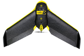
Ebee Unmanned Aerial Vehicle

 Is the City certified to fly in Yellowknife?

Users of UAVs above 250 grams, used within the City limits are required, by law, to obtain an Advanced Operations Pilot Certificate . This certificate must be acquired from the Transport Canada in advance of any flight of the UAV. Each flight plan will also be filed as with NAV Canada prior to any flight.

What training did the City receive to fly the UAVs?

Safety is the primary concern when flying UAVs within the City and all rules regulations will be adhered to. Yellowknife staff members have been trained in the operation of the UAV and all associated safety procedures and precautions by Carto Canada, Spatial Technologies and Arctic Response Canada.

Where will the City be flying?

Initial flights will take place over City-owned land, but will expand to new neighbourhoods and other areas where City initiatives are taking place.  Before any flights on private land, permission will obtained from the landowner.

Can you see in my backyard?

No. Privacy is a high priority to the City and this initiative will in no way compromise that. The UAV will fly at about 30 kilometers per hour, approximately 100 meters above ground. It has no hover capabilities and its camera does not have a zoom lens, so photos will capture broad imagery, not detailed pictures. As an extra precaution, all footage will be reviewed to ensure citizen privacy.

Here is an example of the sample photo collected by the UAV from 100 metres above the ground.

How does the City notify the public of upcoming flights?

Prior to any flight, the City will file a NOTAM (Notice to Airmen) and obtain approval from NAV Canada. These NOTAMs are published on Nav Canada's web page (navcanada.ca).

  • GIS
    Toggle Section GIS Menu
    • CityExplorer (Interactive Maps)
    • Imagery Collection and Assessment
      Toggle Section Imagery Collection and Assessment Menu
      • City Maintained Trail Condition Assessment
      • Road Condition Assessment
    • Map Gallery
    • Open Data
    • Unmanned Aerial Vehicles
  • View Full Exploring Yellowknife Menu
    Toggle Section
    • About Yellowknife
      Toggle Section About Yellowknife Menu
      • How to Get Here
      • Transit
    • Arts, Culture, and Heritage
    • Aurora Forecast
    • Extraordinary Yellowknife
    • Farmers Market
    • Foodies
    • How to Get Here
    • Promotional Videos
    • Self Guided Tours
    • Shop Local Initiatives
    • Visitors Guide
    • Yellowknife Tourism Links

Contact Us

Subscribe to page updates

City of Yellowknife Footer logo

4807 - 52 Street, P.O. Box 580,
Yellowknife, NT, X1A 2N4
Tel: 867-920-5600

  • Living Here
  • Getting Active
  • Exploring Yellowknife
  • Doing Business
  • City Government
  • Newcomer
twitter:d67fd7f6-1a0a-4b39-a73b-0aa0582e8d57

© 2022 City of Yellowknife

PrivacySitemapFeedbackIntranetContact UsHours of OperationCouncil Portal
By GHD Digital
Follow Us: View our Twitter Page View our Instagram Page View our Facebook Page View our YouTube Page

Browser Compatibility Notification

It appears you are trying to access this site using an outdated browser. As a result, parts of the site may not function properly for you. We recommend updating your browser to its most recent version at your earliest convenience.